Location and how to get here
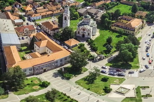
Trstenik municipality is situated in the central part of Serbia, in the fertile valley of the West Morava and on the slopes of the Gledić Mountains and Goč. Approximately 45000 habitants live in 51 settlements. Trstenik is economic, administrative and cultural center of the municipality which has approximately 16000 habitants. In the vicinity of Trstenik, 10 km west of the town is the most celebrated Vrnjačka Banja Spa. 21° longitude goes through the municipality, that line symbolically connects us with the rest of the world in space and time and tell us that we are geographically, historically and culturally part of Europe.
How to get here
Trstenik is at the crossroads of important transportation routes since the ancient times. It is located on the national road Kruševac-Kraljevo-Čačak-Užice, 52 km away from a connection to highway E75 Belgrade –Niš nearby Pojate and 30 km away from the Ibar highway, actually, from the national road for Kragujevac. The nearest airport is “Constantine the Great” Airport in Niš, 100 km away. The airport is 230 km away from Belgrade airport.
The vicinity of Vrnjačka Banja Spa (10 km) and Kopaonik (90 km) has the great significance for the touristic position of Trstenik, as well as the position on the Wine Route. In the vicinity of the town, 2 km east, there is touristic-sports airport “Trstenik”.
If you travel by car, Trstenik can be reached:
- by highway (E-75) Belgrade-Niš, exit at Batočina (115 km), and then by national road via Kragujevac and Kraljevo to Trstenik (92 km);
- by highway (E-75) Niš-Belgrade, exit at Pojate (69 km), then by national road via Kruševac to Trstenik (52 km);
- by highway Ljig-Preljina (E763), then by national road via Kraljevo to Trstenik.
Or if you travel by bus:
- by bus from Belgrade Bus Station (about 11 departures/day; price: about 10 EUR);
- by bus from Niš Bus Station (7 departures/day; price: about 7 EUR)
- by train from Belgrade to Stalać, and then by a local bus.
Bus:
Belgrade Bus Station – Information
+381 11/ 2627-146, 2622-526,180-377 (international bus transport)
+381 11/2636-299 (domestic bus transport)
Niš Bus Station – Information
+381 18 255 177
http://www.nis-ekspres.rs/index_en.php
Train:
These are useful links regarding ticket offices and telephone numbers:
